Skuleskogens National Park
Where the mountains meet the sea
Skuleskogen became Sweden's 19th national park in 1984. Nowhere else in the Gulf of Bothnia is the sea as deep or the islands as high as they are along the High Coast. The beautiful red Nordingrå Granite, the uplifted coastline and the unique conditions for plants that wouldn’t usually grow at these latitudes are typical of the national park. You can reach hiking trails and all the sights from any one of the three park entrances.
Park Entrances
The West Entrance
The West Entrance is in the park's northwest corner, about 300 metres above sea level. This entrance makes the park very accessible to everyone due to its wide paths that are suitable for wheelchairs and strollers. From the car park, there is a wide boardwalk that goes 200 metres into the forest to a large viewing platform with seating, a barbeque area and information on the park and the High Coast World Heritage Site. From here, you can take a well-maintained gravel trail to the viewpoint Nylandsruten – this is also suitable for wheelchairs and strollers. The trail towards Långtjärnhällorna and on further into the national park continues on after about 300 metres.
The South Entrance
The South Entrance is on Moberget’s lush southern slopes and is built on beautiful red Nordingrå Granite. From this entrance you can easily find a place to sit down and admire the magnificent views out over the Bothnian Sea. The High Coast Trail goes through the South Entrance and not far along, it takes a detour down to the sandy beach at Kälsviken, which is a popular swimming and picnic spot on hot summer days. The South Entrance is the only entrance into the park that is open in the winter months.
The North Entrance
From the car park on the national park’s boundary, there is a 70-metre long boardwalk that goes to the edge of the river Salsviksbäcken’s steep banks. Here, at the foot of Krypenberget, surrounded by tall firs and aspens, you will find seating, a barbeque area and information for visitors.
Experiences
From any one of the three entrances in the south, north and west, you can access 30 kilometres of hiking trails and countless interesting places and things to see. The South Entrance is without a doubt the most commonly used entrance into the park. It is closest to Skuleskogen’s most popular sight, the canyon Slåttdalsskrevan. But there are other ways to get to the canyon as well. From the West Entrance, the hike is a little longer but there are advantages to this - you will see a lot more on your way to the canyon. Once you reach the canyon, you can take a break or even a swim in the idyllic Tärnättvattnen, or you may decide to hike up to Slåttdalsberget to see one of the High Coast’s most beautiful views. From the South Entrance you can also take less challenging trails to Näskebodarna or Tärnättholmarna.
Slåttdalsberget
Slåttdalsberget is a mountain made from Nordingrå Granite and has very little growing on it. After the ice retreated, the top of this mountain was just under the surface of the sea, and it has been rising up ever since. As it rose up from the sea floor, thousands of years of waves washed its slopes clean of fertile soil meaning that not much can grow on it now. From the top you have a fantastic view of the sea and surrounding forests.
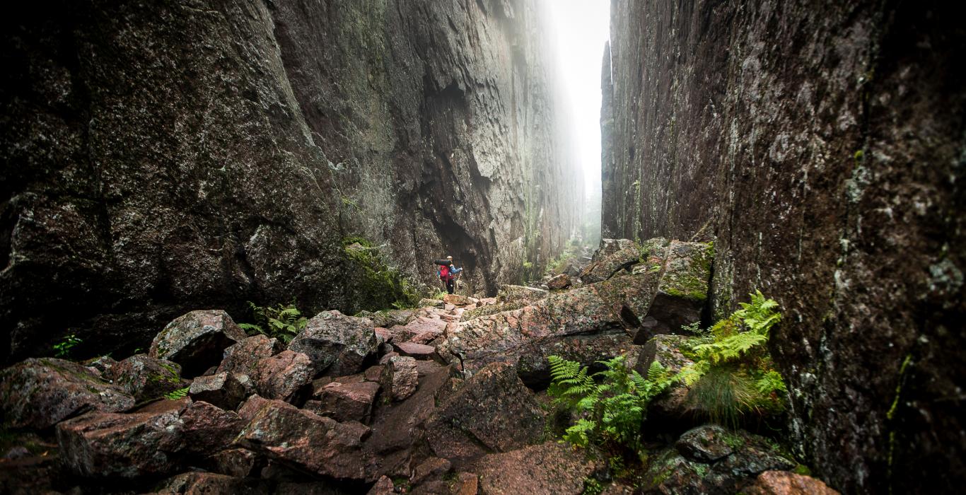
Slåttdalsskrevan Canyon
The northern part of the mountain Slåttdalsberget has been divided in two by a 200-metre long canyon called Slåttdalsskrevan. It is a magic place and must be experienced first hand. The canyon was created 1200 million years ago. Molten magma was forced up from the earth’s core and cooled to rock. It was much softer than the granite of the mountain on each side of it and has since eroded away. Several ice ages, the sea and the land uplift process have helped clear the canyon.
Tärnättholmarna
Clear evidence of land uplift in the region can be seen here at Tärnättholmarna. These small peninsulas are connected by narrow sand bridges to the mainland but not so long ago they were small islands. There are cabins here that can be used for overnighting in. On the outer parts you will find smooth rocks perfect for sunbathing, swimming and picnicking. Tärnättholmarna is a 3.5-kilometre walk from the North Entrance.
Nylandsruten and Långtjärnhällorna
Nylandsruten is about 800 metres from the West Entrance and is a so-called till-capped mountain – it has a forested peak and barren sides due to the peak never having been under the surface of the sea after the last ice age, so it has kept its fertile soils, while the mountain’s sides were washed clean by the waves as it slowly rose from the sea. If you look to the east, you will see another one of these till-capped mountains. The viewpoint here will give you amazing panoramic views in good weather. You can also see a large part of the national park from the Skag Lighthouse in the northeast, the nature reserve island of Trysunda in the east and the Ulvöarna islands in the southeast. At the bottom of the steep slope you are met by the dark reflection of Lake Svarttjärn. Enjoy!
About 1.2 kms from the West Entrance you can take a loop trail around Långtjärnhällorna. This is an easily hiked trail that primarily consists of smooth rocks and board walks. In good weather, you will be able to enjoy fantastic views over the High Coast and the national park.
Näskebodarna
Näskebodarna is a summer grazing farm that was used from the mid 1800s as an outpost for spring fishermen on the hunt for herring. It is about 3.8 kms from the South Entrance to the park and is an excellent day walk. You can barbeque, stay overnight in the cabin or pitch your tent in the meadow. Please make sure you leave the privately owned summer cabins in the area in peace.
Kälsviken
The sandy beach at Kälsviken is popular on hot summer days and is about 1 km from the South Entrance. The sheltered bay and sandy soil are also perfect for tenting.